162.400 MHz - 162.425 MHz - 162.450 MHz - 162.475 MHz - 162.500 MHz - 162.525 MHz - 162.550 MHz
Skywarn
I would be genuinely surprised if no one has figured out by now how much I love skywarn. Weather is my thing. I love to stand outside when the time is right and look the storm right in the eye. So this page is dedicated to skywarn. I have many links for many different things. From RSS feeds to live and continuously updated feeds and our local skywarn chatting network. I have even added tips for spotters.
Amateur Radio at NWS Quad Cities Davenport
Amateur Radio SKYWARN Operations
at the National Weather Service, Davenport Iowa.
The 146.880 repeater is used by National Weather Service as a Quad City Area-Wide collector. Net control operators and individuals are free to have direct contact with the NWS to give severe weather reports 146.880.
Amateur radio is a vital part of the National Weather Service (NWS) SKYWARN system. The instant communication of severe weather reports and other weather information during severe weather outbreaks are an important part of the NWS warning process. Timely and accurate severe weather reports enable NWS meteorologists to issue better warnings. The NWS greatly appreciates the support we have received from the amateur radion community over the years and hope to continue the excellent relationship into the future.
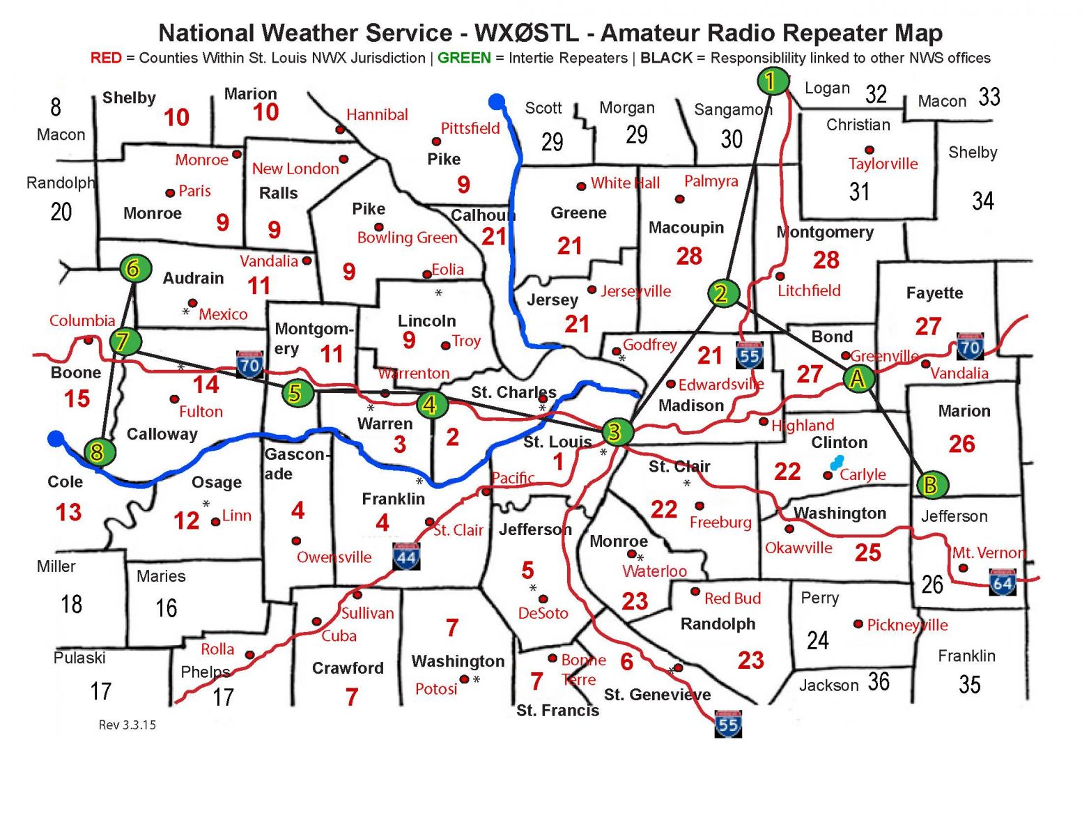
The NWS St. Louis covers 46 counties in Missouri and Illinois. This is known as our County Warning and
Forecast Area (CWA). With a CWA that stretches from Columbia, MO east to Salem, IL, and from Quincy, IL south to Fredericktown, MO, real-time communication across this area can be quite a challenge.
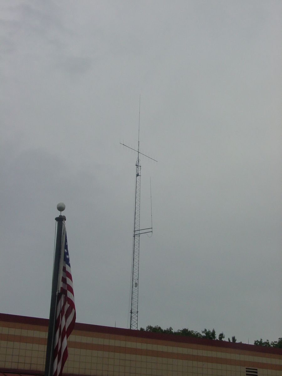
We have expanded our amateur radio operations quite a bit over the years. The first step was the addition of an 80 foot tower to hold our antennas. We have two vertical VHF/UHF antennas, and we recently added a VHF
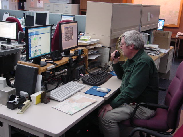
beam on a rotator. This has extended our range quite a bit. We have 4 radios in the office; two 2-meter
radios, and two dual band (2-meter/440) radios. While it would be nice to talk on many repeaters/weather nets individually, that is not always possible. During busy severe weather outbreaks, we simply can't be on all the repeaters in which weather nets are being run. Therefore we have set up a system of set frequencies/repeaters that we always monitior. The idea is to try and get as many amateur spotters and net control operators as possible to come to us instead of the NWS coming to them.
General Operations at the NWS
Since it is often impossible for us to be on every repeater that has a weather net, we have established set
frequencies/repeaters that we monitor 99.9% of the time. Here are the repeaters we monitor.
St. Louis Metropolitan Area direct to NWS: 145.330
Areas north of I-70: 145.190
In Central Missouri, the Missouri Highway Patrol Amateur Radio Club operates a repeater in Linn, MO, Osage County. This repeater has good coverage from Boone, Cole, Callaway, Osage to Gasconade County.
145.390, pl 127.3
Missouri Show-Me Intertie: East Central MO into Illinois.
The Intertie is currently not working from Central, MO to St. Louis. Until it is repaired, spotters in Central Missouri are encouraged to use the Osage County (Linn) repeater to contact the NWS
For areas south of I-70, we will try to hit various repeaters based on where the thunderstorms are occurring. Also based on the storm activity, we will try to hit various repeaters with our 2-meter beam as necessary.
Below is a map of the area we can cover and the frequencies used in each county. Click on the following link for an Excel spreadsheet that gives the repeater frequencies that correspond to the numbers in each County.
Frequency spreadsheet.
Show-Me Intertie
The Show-Me Intertie is a system of UHF repeaters that link the Jefferson City/Columbia, MO area to St. Louis. In early 2008, the Intertie was extended into Illinois. The NWS will monitor the Intertie 99.9% of the time. Below is a map of the MO Intertie system. As of September 2011, the Intertie was not working from High Hill, MO to the Colunbia/Jefferson City area.
Intertie Sites:
Jefferson City: 443.175 (pl=77.0)
Columbia: 444.425 (pl=77.0)
Centralia: 443.025 (pl=77.0)
High Hill: 444.025 (pl=77.0)
Foristell:444.475 (pl=77.0)
St. Louis: 443.475 (pl=77.0)
Net control operators or individual spotters who can reach any of the Intertie repeaters should do so to relay your reports to the NWS.
Illinois Sites:
Gillespie: 444.250 (pl103.5)
Gillespie: 145.290 (pl123.0)
Greenville: 147.165 (pl 103.5)
Net control opeators or individual spotters who can reach either of these repeaters should do so to relay your reports
to the NWS 145.190
Whenever there is severe weather north of I-70 in MO, we will monitor this repeater. It has good coverage across Northeast Missouri. Net control operators or indivudual spotters in this area should try to reach the NWS through this repeater.
145.33 and 146.940
The 145.330 repeater, operated by the St. Charles Amateur Radio Club, is the primary repeater the NWS will monitor for the St. Louis Metropolitan area. Net control operators or individual spotters in the St. Louis Metro Area are encouraged to bring reports directly to the NWS via this repeater.
at the National Weather Service, Davenport Iowa.
The 146.880 repeater is used by National Weather Service as a Quad City Area-Wide collector. Net control operators and individuals are free to have direct contact with the NWS to give severe weather reports 146.880.
Amateur radio is a vital part of the National Weather Service (NWS) SKYWARN system. The instant communication of severe weather reports and other weather information during severe weather outbreaks are an important part of the NWS warning process. Timely and accurate severe weather reports enable NWS meteorologists to issue better warnings. The NWS greatly appreciates the support we have received from the amateur radion community over the years and hope to continue the excellent relationship into the future.
The NWS St. Louis covers 46 counties in Missouri and Illinois. This is known as our County Warning and
Forecast Area (CWA). With a CWA that stretches from Columbia, MO east to Salem, IL, and from Quincy, IL south to Fredericktown, MO, real-time communication across this area can be quite a challenge.
We have expanded our amateur radio operations quite a bit over the years. The first step was the addition of an 80 foot tower to hold our antennas. We have two vertical VHF/UHF antennas, and we recently added a VHF
beam on a rotator. This has extended our range quite a bit. We have 4 radios in the office; two 2-meter
radios, and two dual band (2-meter/440) radios. While it would be nice to talk on many repeaters/weather nets individually, that is not always possible. During busy severe weather outbreaks, we simply can't be on all the repeaters in which weather nets are being run. Therefore we have set up a system of set frequencies/repeaters that we always monitior. The idea is to try and get as many amateur spotters and net control operators as possible to come to us instead of the NWS coming to them.
General Operations at the NWS
Since it is often impossible for us to be on every repeater that has a weather net, we have established set
frequencies/repeaters that we monitor 99.9% of the time. Here are the repeaters we monitor.
St. Louis Metropolitan Area direct to NWS: 145.330
Areas north of I-70: 145.190
In Central Missouri, the Missouri Highway Patrol Amateur Radio Club operates a repeater in Linn, MO, Osage County. This repeater has good coverage from Boone, Cole, Callaway, Osage to Gasconade County.
145.390, pl 127.3
Missouri Show-Me Intertie: East Central MO into Illinois.
The Intertie is currently not working from Central, MO to St. Louis. Until it is repaired, spotters in Central Missouri are encouraged to use the Osage County (Linn) repeater to contact the NWS
For areas south of I-70, we will try to hit various repeaters based on where the thunderstorms are occurring. Also based on the storm activity, we will try to hit various repeaters with our 2-meter beam as necessary.
Below is a map of the area we can cover and the frequencies used in each county. Click on the following link for an Excel spreadsheet that gives the repeater frequencies that correspond to the numbers in each County.
Frequency spreadsheet.
Show-Me Intertie
The Show-Me Intertie is a system of UHF repeaters that link the Jefferson City/Columbia, MO area to St. Louis. In early 2008, the Intertie was extended into Illinois. The NWS will monitor the Intertie 99.9% of the time. Below is a map of the MO Intertie system. As of September 2011, the Intertie was not working from High Hill, MO to the Colunbia/Jefferson City area.
Intertie Sites:
Jefferson City: 443.175 (pl=77.0)
Columbia: 444.425 (pl=77.0)
Centralia: 443.025 (pl=77.0)
High Hill: 444.025 (pl=77.0)
Foristell:444.475 (pl=77.0)
St. Louis: 443.475 (pl=77.0)
Net control operators or individual spotters who can reach any of the Intertie repeaters should do so to relay your reports to the NWS.
Illinois Sites:
Gillespie: 444.250 (pl103.5)
Gillespie: 145.290 (pl123.0)
Greenville: 147.165 (pl 103.5)
Net control opeators or individual spotters who can reach either of these repeaters should do so to relay your reports
to the NWS 145.190
Whenever there is severe weather north of I-70 in MO, we will monitor this repeater. It has good coverage across Northeast Missouri. Net control operators or indivudual spotters in this area should try to reach the NWS through this repeater.
145.33 and 146.940
The 145.330 repeater, operated by the St. Charles Amateur Radio Club, is the primary repeater the NWS will monitor for the St. Louis Metropolitan area. Net control operators or individual spotters in the St. Louis Metro Area are encouraged to bring reports directly to the NWS via this repeater.
|

|
NWS SKYWARN Storm Spotter Program
In most years, thunderstorms, tornadoes and lightning caused hundreds of injuries and deaths and billions in property and crop damages. To obtain critical weather information, the National Weather Service (NWS) established SKYWARN® with partner organizations. SKYWARN® is a volunteer program with between 350,000 and 400,000 trained severe weather spotters. These volunteers help keep their local communities safe by providing timely and accurate reports of severe weather to the National Weather Service.
Although SKYWARN® spotters provide essential information for all types of weather hazards, the main responsibility of a SKYWARN® spotter is to identify and describe severe local storms. In an average year, the the United States experiences more than 10,000 severe thunderstorms, 5,000 floods and more than 1,000 tornadoes.
Since the program started in the 1970s, the information provided by SKYWARN® spotters, coupled with Doppler radar technology, improved satellite and other data, has enabled NWS to issue more timely and accurate warnings for tornadoes, severe thunderstorms and flash floods. SKYWARN® storm spotters are citizens who form the nation's first line of defense against severe weather. There can be no finer reward than to know that their efforts have given communities the precious gift of time--seconds and minutes that can help save lives.
Who is eligible and how do I get started?
NWS encourages anyone with an interest in public service to join the SKYWARN® program. Volunteers include police and fire personnel, dispatchers, EMS workers, public utility workers and other concerned private citizens. Individuals affiliated with hospitals, schools, churches and nursing homes or who have a responsibility for protecting others are also encouraged to become a spotter. Ready to learn more? Find a class in your area. Training is free and typically lasts about 2 hours. You'll learn:
Need help with your Spotter Number or other local information such as a missing class schedule? Looking for our online program?
If you're looking for a class or information about the local NWS program, check find a class in your area for local information. If you need a little more help finding your spotter number or a class schedule, contact your local Warning Coordination Meteorologist. He or she can help you get, find or replace your spotter information and let you know about upcoming classes.Classes are typically held in an office's relatively slow season. Classes are NOT typically offered all year. Schedules vary from office to office. You also can also take our online spotter program. Some local offices also ask that you take a local class to learn about weather unique to your area.
SKYWARN® is a registered trademark of NOAA's National Weather Service. Please read the rules for the usage of the SKYWARN® name and logo.
(Credit https://www.weather.gov/skywarn/)
Although SKYWARN® spotters provide essential information for all types of weather hazards, the main responsibility of a SKYWARN® spotter is to identify and describe severe local storms. In an average year, the the United States experiences more than 10,000 severe thunderstorms, 5,000 floods and more than 1,000 tornadoes.
Since the program started in the 1970s, the information provided by SKYWARN® spotters, coupled with Doppler radar technology, improved satellite and other data, has enabled NWS to issue more timely and accurate warnings for tornadoes, severe thunderstorms and flash floods. SKYWARN® storm spotters are citizens who form the nation's first line of defense against severe weather. There can be no finer reward than to know that their efforts have given communities the precious gift of time--seconds and minutes that can help save lives.
Who is eligible and how do I get started?
NWS encourages anyone with an interest in public service to join the SKYWARN® program. Volunteers include police and fire personnel, dispatchers, EMS workers, public utility workers and other concerned private citizens. Individuals affiliated with hospitals, schools, churches and nursing homes or who have a responsibility for protecting others are also encouraged to become a spotter. Ready to learn more? Find a class in your area. Training is free and typically lasts about 2 hours. You'll learn:
- Basics of thunderstorm development
- Fundamentals of storm structure
- Identifying potential severe weather features
- Information to report
- How to report information
- Basic severe weather safety
Need help with your Spotter Number or other local information such as a missing class schedule? Looking for our online program?
If you're looking for a class or information about the local NWS program, check find a class in your area for local information. If you need a little more help finding your spotter number or a class schedule, contact your local Warning Coordination Meteorologist. He or she can help you get, find or replace your spotter information and let you know about upcoming classes.Classes are typically held in an office's relatively slow season. Classes are NOT typically offered all year. Schedules vary from office to office. You also can also take our online spotter program. Some local offices also ask that you take a local class to learn about weather unique to your area.
SKYWARN® is a registered trademark of NOAA's National Weather Service. Please read the rules for the usage of the SKYWARN® name and logo.
(Credit https://www.weather.gov/skywarn/)
